Should you fish today? Get the read before you spend the fuel, the fare, or the early alarm.
A good captain reads a handful of signs. Fish or Pass reads all of them — decades of ocean science, the fishery’s history, live conditions, and how every species actually behaves — and folds it into one honest verdict: Catching · Fishing · Pass.
Six species · the whole Bight, bank to break · honest about what it can’t know
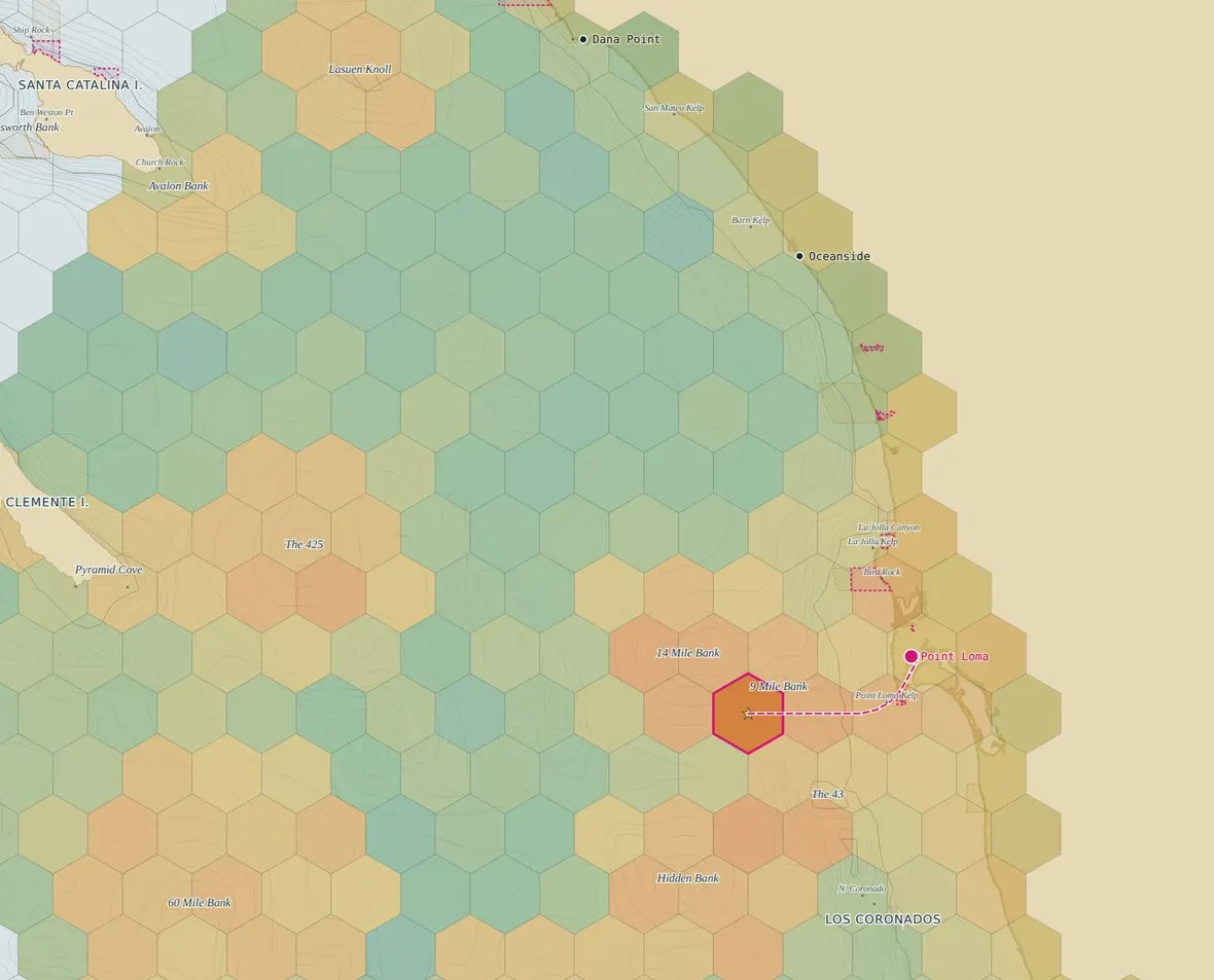
A report card for the water
One score per area, updated daily from six signals a captain reads. A high score means the water and the conditions line up — not that you’re guaranteed a fish.
Built for your boat
Save your vessel and range. The map only counts water you can actually reach and safely fish in today’s sea state.
Every bank & break
The 9 Mile, the Coronados, Cortes, Tanner, Catalina, the Channel Islands — real structure, real depths, real place names.
Honest about the miss
We show confidence and say what the score can’t know. Owning the misses is why captains trust the number.
Start with the fish you’re after
Each one’s tuned to its own temperature band, depth and structure.
More species on the way — white seabass, barracuda & bonito.
Where do you leave from for yellowfin?
Your read is built for the water you can actually reach from there.
Nine home ports — and the banks between them: 9 Mile · Cortes · Tanner · Catalina · the Coronados. All port guides
Six signals a good captain reads — folded into one honest number
These six are the surface. The score draws on the whole of what’s known about this ocean and these fish — decades of records, the fishery’s history, the marine science, live satellite and buoy readings, and how each species actually behaves.
Recent activity
How the fishing’s been going lately in water you can reach — one signal of six, a nudge on the score, never the whole story.
Water temp & breaks
Ocean temperature against each species’ comfort zone, plus the sharp temperature edges pelagics stack on.

Structure & depth
The seafloor a species lives on — banks, canyon edges, and the depth band it holds in.

Kelp & bait
Standing kelp, paddies and bait marks — where calico and yellowtail set up.

Sea conditions
Swell and wind scored for your hull — a snotty day is a lower score for a small boat than a big one.

Moon & tide
Phase and exchange for the region — the small, steady nudge on the bite.
What the score can’t know — and we’ll tell you
A satellite pass can be cloudy, reports lag, and fish move — so Fish or Pass is a conditions report card, not a guarantee, and not a safety or navigation tool. Every read carries a confidence indicator; always check official NOAA marine forecasts and use your own judgment before you head out.
Try it free for 7 days. Keep it when the forecast pays for itself.
Every plan starts with the same 7-day free trial — no card to start. One saved trip covers the month.
The daily Bite Score, all six species, your ports and boats, and the core chart views.
- Daily Bite Score, verdict & full “why” breakdown
- All six species · your ports & boats
- Today + 1-day & 3-day forecast · best-bite windows
- Chart views — water temp, chlorophyll, temp breaks & kelp
- Full SoCal Bight + all banks · 5 nm map detail
- Daily report-card email
- MPA + regulation overlay
Everything in Angler, plus alerts, custom routing, extended range and the full chart overlays.
- Everything in Angler, plus:
- Mexican waters — the Coronados & south
- Custom threshold alerts — pinged the morning it fires
- 5–7 day + hourly best-bite windows
- Waypoints & custom routing — plot a run through the hot spots
- Structure overlay — real seafloor & bathymetry
- Weather overlays — wind & swell on the chart
- 3 nm map detail
Multiple captain seats, fleet-wide boat data, and priority support.
- Everything in Captain
- Multiple captain seats & roles
- Fleet-wide boat data & analytics
- Onboarding & priority support
- Volume pricing
Every plan starts with a 7-day free trial — no card to start, and no charge until it ends.
Safety is never gated — MPA boundaries, regulations and the go/no-go sea-state call are in every plan.
Captains who stopped guessing
Founding-member reads from the SoCal fleet. We swap these for verified reviews as they come in — and we never fake a report.
Called a Pass on a day I would’ve run to the 9. Saved me a hundred bucks in fuel and a 4 a.m. wake-up for a dead ocean.
— Private boater · Point Loma · founding member
It knows my Parker’s range, so it’s not teasing me with water I can’t reach. The “why” breakdown is what sold me — it’s not a magic 8-ball.
— Weekend angler · Dana Point · founding member
Finally something that says “sit this one out” and means it. That honesty is exactly why I trust the green days.
— Charter captain · Oceanside · founding member
We got tired of guessing.
Fish or Pass started with the expensive question every SoCal angler asks at 3 a.m.: is it even worth going? A tank of fuel, a lost morning, a bluebird ocean — the misses add up. So we built the tool we wanted: a daily, honest read on the water, from the same things a good captain reads. Not odds. Not a promise. A grade you can interrogate.
Vessel data is powered by Set Sale Marine, so your boat’s real range and sea-handling shape the map.
Our one rule
Never spend the reader’s trust. We don’t invent a bite report, a catch count, or a data reading — ever. If we don’t have the number, we describe the pattern. We’d rather tell you to Pass than sell you a day that isn’t there.
The honest FAQ
+ − Is this “odds” of catching fish?
No — and we won’t call it that. Fish or Pass grades conditions: how the water and the recent reports line up for a species and area today. A high Bite Score means the setup is strong, not that you’re guaranteed a fish. The ocean always gets a vote.
+ − What area and which fish does it cover?
The Southern California Bight — Point Conception to the Mexican border, the Channel Islands, and the offshore banks. Six species today: bluefin, yellowfin, yellowtail, dorado, calico bass and rockfish, with white seabass, barracuda and bonito on the way.
+ − How does it know what my boat can do?
Save your boat — make, range, cruise and sea-handling. The map then only counts water you can actually reach and safely fish in today’s swell and wind, and the run distance factors into the score. A 22-footer and a 39 Yellowfin get different maps.
+ − Where does the data come from?
Real, mostly public sources — ocean-temperature and weather models, tide and moon data, seafloor charts, and how the fishing’s been reported lately — blended through our own model, with a confidence indicator on every read. We weigh recent activity as one signal; we don’t republish any single shop’s numbers.
+ − Can I try it before I pay?
Two ways. Pick a fish and a harbour on this page and you’ll get a real Bite Score and the full “why” breakdown — no account, no card. And every plan starts with a 7-day free trial: no charge until it ends, cancel anytime.
+ − Can I trust it for safety?
Never use Fish or Pass as a safety or navigation tool. It’s a fishing-conditions planning aid, not a substitute for official NOAA marine forecasts, the Coast Guard, charts, or your own seamanship. Regulations and MPA lines are shown for convenience — CDFW is the authority; confirm before you fish.
Stop guessing. Get today’s read on the water.
Seven days free. Real score, your boat, your ports — keep it the day the forecast saves you a trip.